

The Weather Forecast
We are having to get used to the frequency and ferocity of storms. We have currently experienced more than seven storms this winter already. With this information in mind, I was very interested in an article about a shipwreck off Porth Alerth near Moelfre on Anglesey that was instrumental in the creation of the shipping forecast. As often happens, tragedy leads to a catalyst for change.
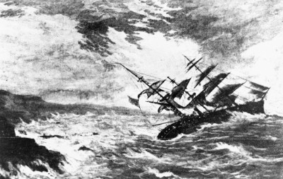
In British weather history, the Royal Charter Storm of 1859 was a devastating tempest off the west coast of Britain which played a pivotal role in the founding of the shipping forecast and has had an enduring impact on weather forecasting in the UK and beyond.
Winds gusted at 100 miles per hour between October 25 and 26 that year which was higher than any previously recorded in the Mersey, in north-west England and it’s considered to be the most severe Irish Sea storm of the 19th century. More than 800 lives were lost, and the storm sank or badly damaged more than 200 ships. More lives were lost in this storm than in the whole of 1858. But it also paved the way for the creation of the shipping forecast.
The storm is named after the most famous of the ships lost to the waves, a steam and sailing ship called the Royal Charter. After a two-month journey from Melbourne in Australia, the Royal Charter was heading towards Liverpool with its valuable cargo of gold. The ship was caught in the full fury of the storm off the coast of Anglesey, Wales.
Despite the crew’s valiant efforts to anchor the ship and cut its sails, the Royal Charter was driven onto the rocks in the early hours of October 26. With the help of villagers onshore, they succeeded in saving around 40 passengers. Other passengers had tried to swim to shore but were weighed down by the gold in their pockets and drowned. The ship eventually split in two and the waves claimed the lives of more than 450 passengers and crew members, including all the women and children aboard.
The tragic loss of life and property made the storm headline news. It even came to the attention of Charles Dickens who was working as a journalist in London at the time and visited the site of the wreck soon after the storm.
The shipping forecast and The Met Office
Weather observations had been collected from around the British coast since 1854 by a part of the UK Met Office known then as the Meteorological Department of the Board of Trade. The Royal Charter Storm, however, highlighted a need for more accurate weather forecasting and a national storm warning system.
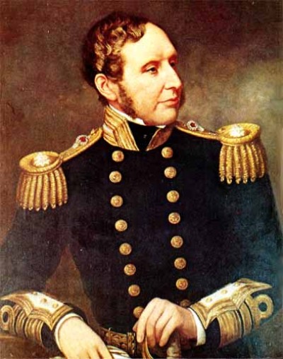
Vice Admiral Robert FitzRoy, a fascinating figure, probably better known as captain of HMS Beagle on which Charles Darwin sailed to South America, was the founder of the Met Office and had been lobbying for the creation of such a storm warning system since the summer of 1859. Following the Royal Charter storm, FitzRoy was able to demonstrate that it could have been predicted. In December of that year, the new storm warning system was approved, and the first warning was issued in February 1861.
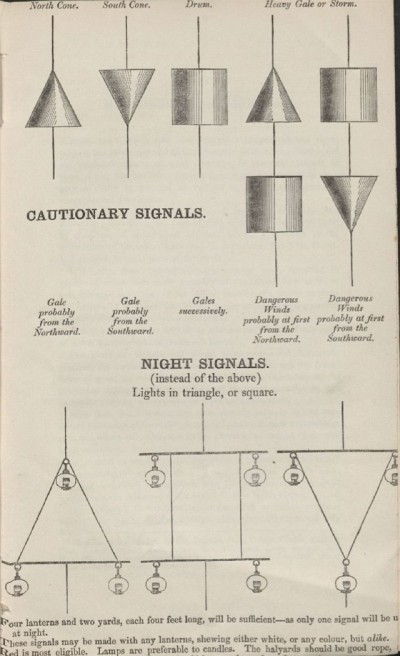
The storm warning was delivered by telegraph to harbour towns, then cones and drums were hoisted on a mast to warn vessels in harbours and along the coast of the incoming storm. This system has now morphed into the shipping forecast and is the longest running national forecasting service in the world.
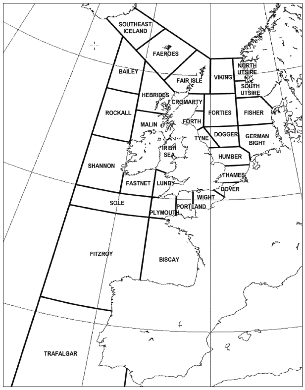
The Shipping Forecast started up on radio in 1924, using 13 maritime zones, broadcast twice daily on the Home Service. It was suspended during the Second World War but was relaunched in 1949.
The boundaries of the sea areas are defined by the plain black lines and these areas are sub-divided into districts named after islands, rivers, or banks within them. This is so that they may be easily memorised and are at once identifiable areas to the mariner.
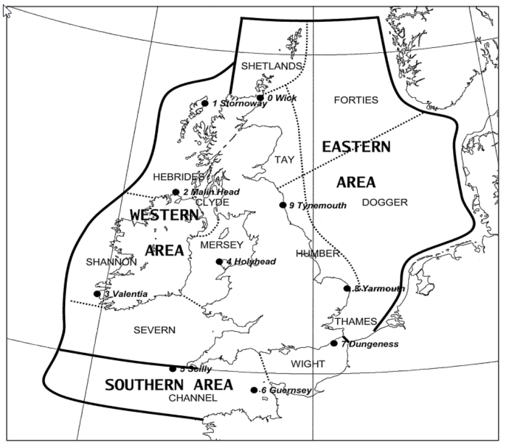
Today, the Met Office provides the shipping forecast on behalf of the Maritime and Coastguard Agency and issues a forecast four times a day for the 31 areas of sea around the British Isles.
Some Facts About The Forecast and Zones
- The 31 zones are given out in strict order, beginning at Viking in the north-east bordering Norway, and proceeding in a clockwise direction round the British Isles.
- The forecast contains details of gale warnings in force, a general synopsis and sea-area forecasts containing forecast wind direction and force, weather and visibility.
- There is an upper word limit for the forecast imposed by the BBC of 350 words.
- Only seven areas survive from the original list: Forties, Humber, Dogger, Thames, Wight, Shannon and Hebrides.
- Minches was absorbed into Hebrides in 1983; North and South Utsire were added in 1984; and in 2002, Finisterre became FitzRoy, named for meteorologist Admiral Robert FitzRoy. The change provoked an outcry, but the accolade is justified.
- Prime cod-fishing ground, Dogger Bank (its name comes from the Dutch ‘dogger’, or fishing vessel) is a 160-mile-long mass of underwater sand dunes, some of which are as tall as Nelson’s Column.
- The dangerous waters around the Farne Islands conceal many wrecks, including the Somali, a steamship bombed in1941.
- The north and north-east Norfolk coast (Humber/Thames) holds some 225 wrecks, including HMS Umpire, a Second World War submarine lying 65ft deep 12 miles off Blakeney Point.
- More wrecks lie on Goodwin Sands off Kent (near Dover), a 10-mile-long series of underwater dunes and banks, a hazard for shipping for centuries.
- Forty miles north of Anglesey is one of the least accessible wrecks, the steamship Liverpool, sunk by a mine in 1916.
A Lasting Legacy
In addition to its meteorological legacy, the effects of the storm can still be seen around the Welsh coastline to this day. On Anglesey, the graves of those who died in the wreck can be found in many churches along the coast. Gold nuggets have also washed ashore in recent years.
Further south, in Cwmyreglwys, Pembrokeshire, stand the remains of Saint Brynach’s church, which was partially destroyed by the storm.
Since 1859, the Met Office has made significant strides in the field of meteorology. In August 1861, the first public weather forecast was printed in The Times, then broadcast on the radio in 1922 and was eventually seen on television for the first time in 1936.
Step by step, the Met Office has pioneered new technologies by launching the world’s first meteorological satellite in 1960 and using the first forecast by a computer in 1965. It has continued to invest in state-of-the-art supercomputers to improve severe weather and climate forecasting since then.
Today, the Met Office is a globally recognised authority in meteorology and climate science. Its expertise is invaluable for numerous sectors, from aviation and agriculture to emergency services and infrastructure planning. The Met Office is now responsible for providing the National Severe Weather Warning Service, which includes warnings for wind, rain, thunderstorms, lightning, ice, fog, snow and extreme heat.
Through the Met Office’s dedication to scientific research and accurate forecasting, the UK and the world have benefited from improved weather predictions and increased preparedness for extreme weather events. The legacy of the Royal Charter Storm lives on in the Met Office’s ongoing mission to provide essential weather and climate services, safeguarding lives and livelihoods in an ever-changing climate.
There are plenty more interesting facts about the progression of the shipping forecast to be found in the National Meteorological Library and Archive.
Information also gleaned from ‘the Conversation’ website
Contributed by Bernice
(Published on 31st Mar 2024)


